

On YouTube I found an episode of Most Haunted from 2005 in which they visit the studios and outdoor set of Coronation Street.
The studio is built on a former graveyard they claim. This is not the 1960’s Granada block but a studio that was constructed next to Lower Byrom Street in the late 1980’s.
It’s a good story, but a quick look through some photographs on the Manchester City Council local image library suggests it isn’t true.
 |
| The site of St. John’s Church now. Photo date: November 2008 |
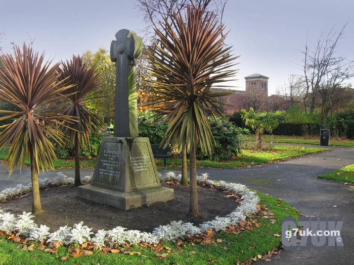
On the other side of Lower Byrom Street, from the studios, is a park that has featured in Coronation Street occasionally. On this site stood St. John’s church and this was indeed surrounded by a large churchyard.
In this photograph from 1914 you can see that the area was covered with hundreds of headstones lying flat.
22,000 people were buried in this area say Most Haunted and they claim that these burials ‘most definitely’ stretched across the road onto the current Granada site. But where is the evidence?
 |
| The site of St. John’s Church now. Photo date: November 2008 |
In this archive shot at bottom left you can see the tower that is now inside the Granada studios area. You can see there is a building in front of it. And above you can see it in my recent photograph. On closer inspection I think the tower may have been rebuilt when the new studio was put up, but very likely on the same spot.
|
|
|
||||
|
|

This shot from 1914 shows Lower Byrom Street along the right side of the picture. The camera looks towards Liverpool Road. The row of buildings on the right of the street are where the current Coronation Street studio is and further down is where the Museum of Science now stands.
In the photograph there does seem to be a gap and a wall. But no more than the width of a couple of houses. In the ‘Imperial Gazetteer of England and Wales’ (1870-72) John Marius Wilson writes:
‘The original station of the Manchester and Liverpool railway occupied a large area bounded by Liverpool-road, Lower Byrom-street, Charles-street, and Water-street.’
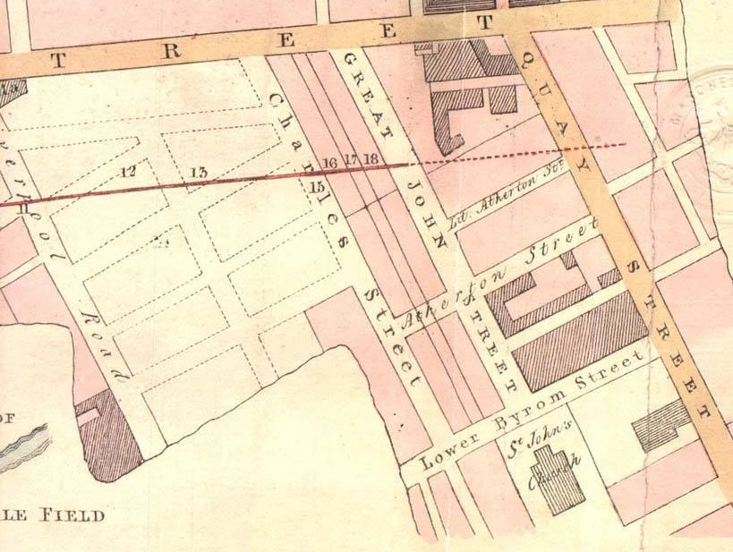 |
| A map from the period when they were planning the route of the railway (Liverpool Road Station opened in 1830). |
The Granada studio building in question is on the corner of Lower Byrom Street and Charles Street (which is now within the fenced-off Granada area). So where were the graves on this side of the road? Most of those 22,000 people would have been buried after the industrial revolution started: from about 1825 onwards. The Victorians would hardly have built on such recent graves, yet there is a row of houses on the spot in 1914.
Look at other burial grounds in the city centre, which date from the same period, such as Rusholme Road Cemetery and nearby All Saints and they are all still parks or grassed areas even now.
Around 1924 the roof of the church collapsed. It was rebuilt but then, bizarrely, the church was demolished in 1931. Looking at this aerial view, from 1930, the headstones may have been removed by then and the area grassed over.
It’s hard to tell from this small black and white photo. But it gives an idea of the position of the churchyard. The studio site is out of shot, bottom left. Here’s a modern-day aerial view.
Is it possible that 22,000 people were buried in the churchyard shown? Bear in mind that in the mid-19th Century, poor people wouldn’t get a proper burial plot. At All Saints Church, Oxford Road, just across the street from the Chorlton upon Medlock town hall, there were common graves that were only temporarily covered, so that new bodies could be put in at intervals until the grave was full. The foul smells that lingered around the church due to this were considered a health risk.
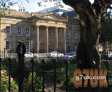 |
| The former Chorlton upon Medlock town hall (only the front remains). Today the ‘park’ in front of it is a pleasant place where students sit on the grass having their lunch. |
Even in proper plots, gravediggers would break up coffins and bodies so that more could be packed in. In fact there was a scandal about this in Britain as recently as the 1970’s.
On the other side of Oxford Road was Rusholme Road Cemetery. It opened in 1821 and is now a park called Gartside Gardens. By 1839, there had been 29,000 burials. Admittedly this is a larger area of land than the St. John’s churchyard but not enormous. It is about 350 x 225 yards. However burials continued at Rusholme Road for another hundred years until the 1930’s. So imagine how many tens or even hundreds of thousands were packed in there in that time.
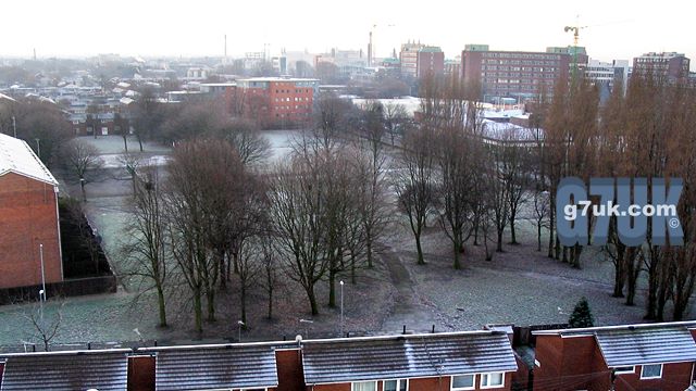 |
| How Rusholme Road Cemetery in Chorlton On Medlock looks today. Here’s a photo from 1963, from a similar but much lower camera angle. The road in the foreground (Rusholme Road) disappeared as part of the slum clearances of the 1960’s. It was where the row of houses is at the bottom of this modern day picture. |
Living in a Manchester that is modern, relatively clean, with quite a few green spaces, it’s hard to imagine the filth and squalor there was here for most people 150 years ago. Average life expectancy in the city centre was very low…
Update: a new website lets you lay old maps over a modern map or aerial image. The maps go back to 1772 and still there is no graveyard to be seen on what is now the Granada site.
A Wikipedia page about Granada Television cites The Sun newspaper as a source for the graveyard story. But is a tabloid newspaper really a reliable source? The page refers to a “paupers grave”, but where is the evidence for this? I have yet to see any.
1 Comment
I grew up just off Rusholme Rd in the 40s/50s. leaving there in Sept 1957 aged 12. Rehousing. We moved to leafy Fallowfield, with a bath, hot water, everything that my parents wanted. I hated it. I wanted to be back in the cobbled streets, and back yards with my pals.
I lived about 150yds from the cemetery, and in the early dark nights, wee used to climb over the railings, and terrify ourselves wandering round all the gravestones. They turned it into a park just before we left so I didn’t get to use it much. Anyway I preferred Ardwick Green Park as it had,(according to the Parkie) a meteorite that had landed there from outer space. It is still there.
I was back there recently in June 2008 wandering round, and remembering through VERY rose coloured glasses, a childhood of not quite poverty. (We had electricity downstairs, but nothing up stairs. Just candles in proper candle sticks.) Most of the street were on gas.I do not ever remember going to bed hungry. Cold , yes, even though myself and my two brothers, who slept in the same bed, had two army and one airforce greatcoats on. I could carry on for hours . I really enjoy your website. And I hope someone might read this who lived there as well.
2 Trackbacks and Pingbacks