

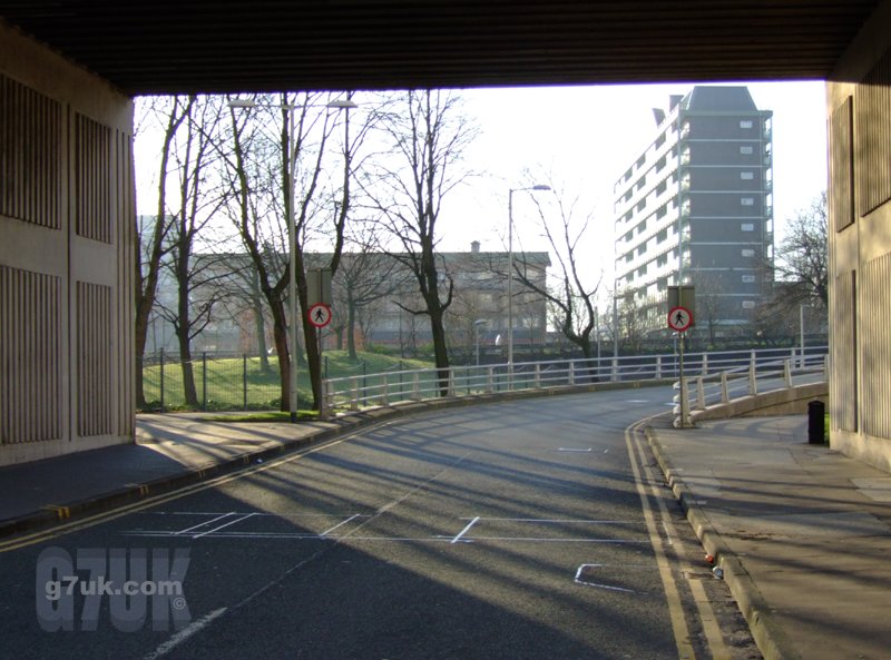
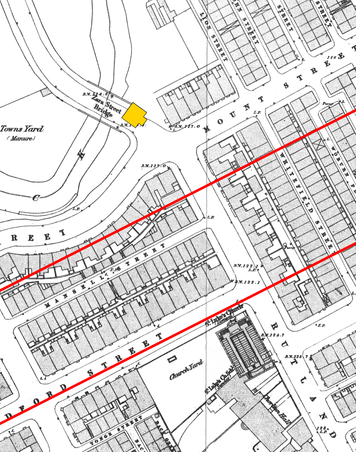
In Victorian times, the southern part of Sackville Street was called Zara Street. The road used to run right into the north-eastern part of Chorlton On Medlock and, after crossing Mount Street, was called Rutland Street.
Later, Rutland Street was renamed St. Luke’s Street. Then, in the 1960’s, the Mancunian Way (motorway) was built and sliced across the area from east to west, cutting off this part of Chorlton On Medlock from the city centre to a degree.
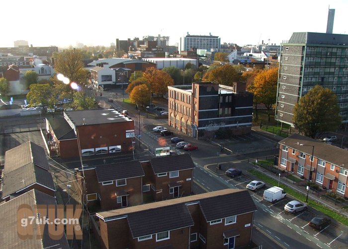
This is how things looked in 1916 and here is a photo taken from the same spot this month.
This map is from 1849. The yellow symbol shows roughly where the camera was in both photographs, old and new, and the red lines show where the Mancunian Way runs today.
Here’s a shot from 1916 looking in the opposite direction up Sackville Street. On either side in the foreground are the low walls of the bridge over the River Medlock. On the map above it is shown as the ‘Zara Street Bridge’.
Chorlton On Medlock (or Chorlton UPON Medlock) covers a fairly large area from Stockport Road in the east, Hathersage Road in the south, Cambridge Street in the west and almost into the city centre in the north. Just to confuse matters, the north eastern part is sometimes referred to as Brunswick. In the nineteenth century this north-eastern area near Sackville Street had a mix of factories, mills, chemical and dye works and poor terraced housing, along with some grand houses along the front of some of the streets. As the century progressed and the area became ever more industrialised, the wealthier people moved further out of the city, leaving the poor behind.
The air was thick with smoke and filth. There were outbreaks of cholera, especially amongst the houses that bordered the River Medlock (this photo was taken from Downing Street looking west). Nowadays you may be lucky enough to see a heron in the river, but 150 years ago it was a toxic soup of chemicals, sewerage and other waste. It wasn’t uncommon to find dozens of families sharing a single outside toilet or cold water tap.
When you weren’t at your 84-hours-a-week job in a factory or at one of the ‘dark satanic mills’ you might be at one of the many churches in the area. Such as St.Luke’s.
Grosvenor Street was a focal point for religion, with a number of churches and chapels, the Salvation Army and a “Funeral Furnisher” on the corner with Downing Street. The business can be seen here in 1890 and was still there in 1958 with the same family name (Broome).
The Rusholme Road Cemetery (Dissenters’ Burial Ground) was just one block away. It opened in 1821 and in the first 18 years there were more than 29,000 burials. By the time it closed in 1933, there had been at least 78,143. Though in 1947 a custodian told The Guardian that “over 100,000” people lay there.
Here’s a shot of St. Luke’s church from 1957 and another from 1959, by which time many of the houses had been demolished. The photographer had his back to Downing Street when he took these two photos.
You can see the church on the 1849 map. However it seems this was an earlier building and it was rebuilt with the spire shortly after that date.
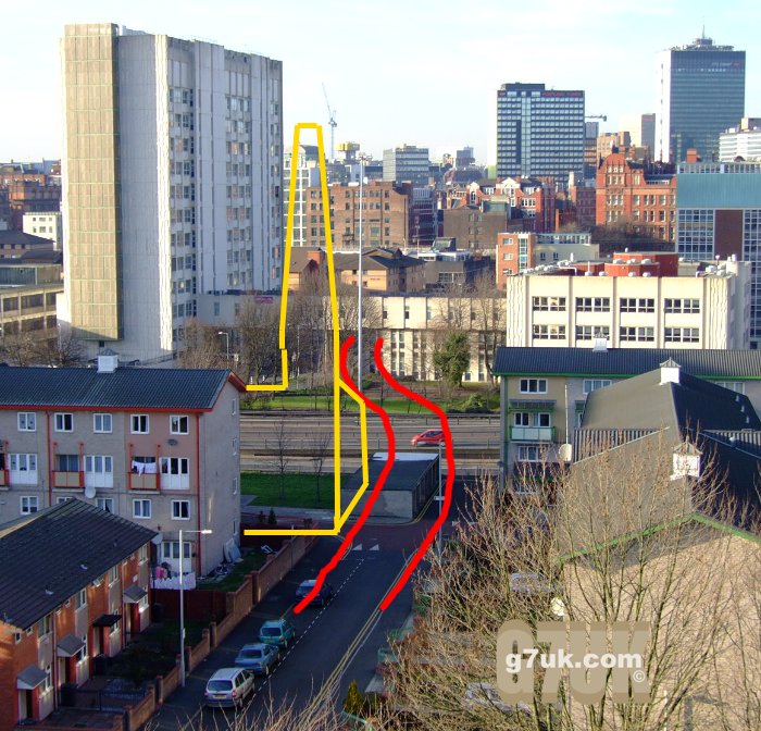
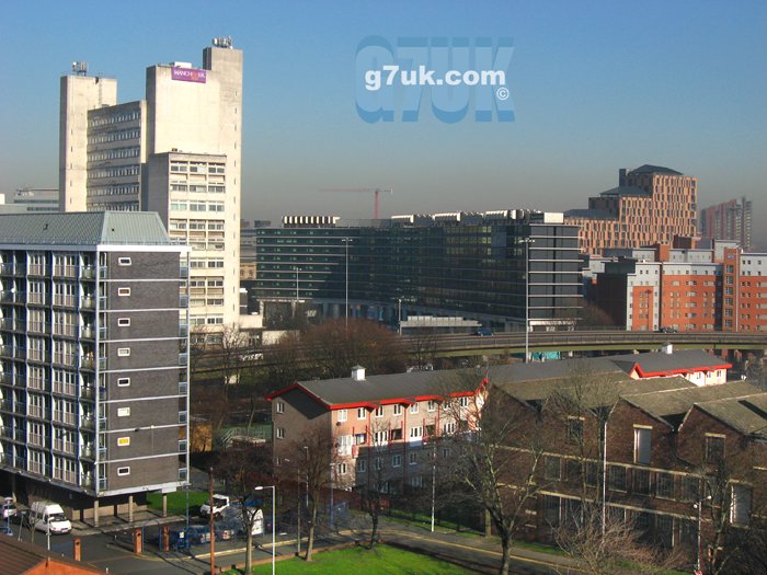
In the modern-day photo above the approximate positions of Sackville Street and St Luke’s Church are marked in red and yellow. Note the patch of grass next to the Mancunian Way, which is where the graveyard of St Luke’s was.
Here’s a shot from 1960 looking towards the city centre and similar to the modern day picture above. However the camera position is a little further to the left. You can see the rear of St Luke’s and its spire on the right of the photo.
Note the distinctive red brick Manchester University building at the top right corner of the modern shot and top left of the archive shot. This photo was taken at the same time (the vehicles are the same in both) and shows the tower of Piccadilly Plaza (now called City Tower) under construction in the distance. Here’s another image showing the scene slightly further to the left (west).
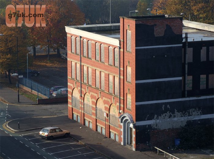
The information on one of these pictures states that they were taken from the roof of 68 Grosvenor Street, which I think may be this building. It’s in the right position and one of the few that is still there now, although boarded up and neglected. Here’s how it looks today:
Here’s a shot looking east towards Downing Street and Piccadilly Station. Note the spire of St Luke’s in the foreground and the box shaped building in the middle distance on the right side of the picture. This is an electricity sub-station apparently and is right next to the entrance to Manchester’s one-time top-secret cold-war atom bomb shelter: the Guardian tunnel.
And it seems the photographer turned to his right slightly and got this shot which shows the rear of the buildings along Grosvenor Street.
Note the factory with the zigzag roof in the top middle of the photo. Here it is today from a different camera angle.
Looking over to the west from the same roof, this vintage shot shows Upper Brook Street with the junction with Grosvenor Street just out of frame to the left. This is how that junction looked in 1959 (the vans at the traffic lights are travelling towards the west along Grosvenor Street). Here’s how the same scene looks today:

This image shows those buildings under demolition in 1960. However the photographer has printed the negative the wrong way round (or it has been scanned that way) so the scene is flipped horizontally.
And here’s the other side of the junction in 1959. The road leading away from the camera is Upper Brook Street heading towards the city centre. In the similar modern-day view below you can see the same building at far left of frame.
If you look at the chimneys you can see how many buildings were demolished to widen Upper Brook Street: the buildings on the corner at the junction, the lower white building and the taller darker building to the left of it were all pulled down. With only the one to the very far left of the old photo still remaining today.
Road widening was one of the things that contributed to the destruction of communities up and down the country, as whole stretches of shops were swept away.
According to a note on one of the photos in the Manchester Libraries collection, when he was in Manchester Charles Dickens used to attend a smaller chapel that was just behind the Rusholme Road Congregational Chapel. The latter stood on the corner of Upper Brook Street and Rusholme Road. Here is a similar image that gives more of a glimpse along Rusholme Road and here is the modern day scene.
The Chapel was where the red-brick house (gable end) is today on the left side of the photo and extended up to where the lamp-post is.
Upper Brook Street is now much wider than it was in those days and Rusholme Road disappeared completely in the 1960’s, along with almost everything else in this part of Chorlton On Medlock. They called it ‘slum clearance’ and much of the housing that was bulldozed was poor. But decent buildings were swept away too.
Similar houses survived in other areas. If they were still around, some of those large terraced houses would sell for £250,000 now (examples: 1, 2, 3, 4). But, even if they had survived the clearance, some of them would no doubt have fallen into dereliction or even been abandoned completely in the following years, as happened in other areas of Manchester during that time.
Today this inner-city area still has a good sense of community. It’s home to an incredibly diverse range of different cultures and nationalities and all get along well together. Here’s a colourful ‘flags of the world’ parade by local children from 2006:
LINKS
Spinning the Web: Cottonopolis – Chorlton on Medlock
This page is mainly about the area of Chorlton On Medlock to the west of Oxford Road.
117 Comments
thank you i thought pictures of chorlton on medlock i thought every thing was gone i went to the school next to st lukes church i forgot the name if you know it let me know thanks roger
Interesting site, thank you. I lived in Chorlton on Medlock as a child and although many of the streets I knew as a child (Spring Street, Summer Street etc, off Upper Brook Street) were indeed slums, the slum is still alive and well in the area. I myself grew up in Upper West Grove and though I would love to tell you of the fond memories I have of the place, this simply wouldn’t reflect reality. Thank god for education and aspiration. And thank god there was, even then, plenty to stimulate a child’s mind. My brother and I used to know the museums and galleries by heart. Hathersage Baths was also just around the corner.
The Groves are still standing and still a blot on the horizon. My father still lives there. When I was a child in the early sixties, we still had the old air-raid shelter. Conditions were truly grim.
It was interesting to hear that Charles Dickens had visited the area. He must have felt very at home!
hi i was wondering if anyone knows what year thay took the top of steeple of st luke’s church , i was a boy siting in the class room i would see the big stones come down but dont know what year it was thanks harry
g7uk.com: There are some photos of the classrooms on the Manchester Libraries website:
http://www.images.manchester.gov.uk/
Search for “St Luke’s Church”.
There don’t seem to be any exterior shots earlier than 1959 on the website.
Speaking of dark satanic mills, I was back in the UK recently and had a stroll down Grosvenor Street towards Ardwick. I was surprised to see that several of those old buildings were still working as textile and clothing factories. Sadly, two of the companies were named and shamed as sweatshops in the recent Primark purchasing scandal. So, not much has changed in the intervening 100-odd years !
Interesting site. Thanks.
Good site – lots of info – am in process of writing piece about my childhood in C-on-M (Robert Street). Went to Mansfield Street School.
It was regarded as a slum area but many houses were quite good and sound. They would have benefitted from modernisation. Good community to grow up in.
Thanks.
I am looking for any Prendergast family members.they lived in the area at the turn of the century, in Rutland Street.No 5 I think.I am living in Australia, moved here in 1962 so its difficult to find out anything. Anybody know anything,thankyou.
g7uk.com: Shirley it seems there was a Rutland Street in Hulme and another one in Chorlton On Medlock. Did you click through and see the 1916 photo that I mention right at the top this page? That shows the top of Rutland Street where it joined Mount Street in Chorlton On Medlock. And my modern-day photo at the the top of this page is from the same viewpoint.
Thanks to everyone for all the comments and information. I plan to do some more photo articles about the area.
Fab site, my gt gt grandmother (Catherine Gerrity) lived at 41 Robert Street (died there in 1906). Is it still there? I cant see it on a road map.
g7uk.com: Dave there was a Robert Street in Chorlton On Medlock and another one not far away in Ardwick. The Robert Street in Chorlton On Medlock ran parallel to the south east side of the Rusholme Road Cemetery. From Upper Brook Street probably over to Downing Street (I can’t see that far on my map).
Just about everything in the area was cleared in 1963. Only a few pubs, a church and a couple of warehouses were left. However Robert Street ran along one side of the King’s Arms pub and the building is still there. It is where the two cars are parked in the Street View below.
Here is how the pub looked in 1959.
There was also a Queen’s Arms pub on Robert Street. Seen here in 1959.
Shirley, Are you a descendant of Harry Prendergast? He lived in Chorlton as a youngster and had a son called Sydney who then had two daughters named Denise and Shirley. If so, have some information on Harry which may be of interest
I am a descendant of Jack Norman Davies (born at 1a Ripon St 1923) his parents were George Walter Davies and Florence Thompson. Does anyone know any descendants of either Julia Davies or Eveline Hawley (married Tom Hawley) or any descendants of Tom Warren Thompson and Sarah Alice (nee Crimes) (these 2 were Florence Thompson’s parents). Also, if someone died in Chorlton upon Medlock or Fallowfield, where would they likely be buried? (Before 1960). Thanks
GS, Glad you took the trouble to host this site. The ‘Comments’ have yielded enough clues to find the addresses of my ancestors. e.g. Mawson St, Cottenham St, Higher Temple St, Robert St.
My dad was born on Higher Temple St. in 1905 – – – his Registration bears the signature of Emmeline Pankhurst !
Keep up the good work
The late Mr James Sperring of Moss Side
It’s interesting to know that my 3rd great grandfather, who worshipped at the Rusholme Rd Congregational Church for 40 years, may have known about or even seen the famous Mr Dickens on one of his visits.
Mr Sperring was also the secretary for the “Sackville Street Ragged School.” I’ve not to date been able to verify the existence of such a place. Is Sackville street in this area as well? and if so, whereabouts?
Does anyone else have information on either Sperrings in Manchester or know about a Ragged School in Sackville street?
Thanks
g7uk.com:
in reply to Geoff, great to have a connection to such a historic figure! Here is the corner of Brunswick Street and Higher Temple Street. If you click New Search on that page and search for Higher Temple Street there are a couple of other shots (I think the photo labelled ‘Higher Temple Street steps’ should just be ‘Temple Street steps’ as that is right at the northern end near the railway viaduct).
In reply to Jane, Chorlton upon Medlock is quite a big area. They could have been buried in the Rusholme Road cemetery which was probably the largest in the area, or in Ardwick cemetery which was renamed Nicholls Field in 1966. I’m not clear when burials ceased in those two. Before 1881 they might have been buried at All Saints church on Oxford Road.
There was also a churchyard at St. Luke’s church (Roman Catholic) on St. Luke’s Street (earlier known as Rutland Street). Also a number of burials at Grosvenor Street Chapel (General Baptist) which was at the south east corner of the junction of Grosvenor Street and St. Luke’s Street (I’m fairly certain that photo shows it but it’s a bit confusing because there is also this photo and I’m not sure whether that is the same Chapel or a different one). I don’t know much about Fallowfield unfortunately.
In reply to Gill, here is part of the 1849 Ordnance Survey map showing Zara Street.
At the time, if you had walked north up Zara Street as far as Canal Street you would then have been walking on Sackville Street. However, at some point the name Zara Street was done away with, the whole street became Sackville Street and still is.
This photo shows ‘Chorlton on Medlock Ragged School near Temple Street’.
Temple Street was just 150 yards west of Zara Street/Sackville Street and between the two was School Street.
I looked at the 1955 Ordnance Survey map (which I can’t post here because it is in copyright) and it shows ‘Jackson Street Ragged School’ on the corner of Holt Street and Jackson Street. I’ve marked the position in yellow on the 1849 map above. The 1849 map shows a building which is a similar shape, but it has no label.
Here is another picture of the same school. This photo also shows a Ragged School in Chorlton on Medlock.
I wonder if a Ragged School would have been on a main street like Sackville Street? I reckon more likely it would have been in a back street close to the mills? So I wonder if the Jackson Street school is the one you are looking for?
The area was cleared in the early 1960’s and new buildings constructed for the Manchester College of Science and Technology (later called UMIST). Now it is part of Manchester University and plans are afoot to redevelop the area yet again! But that must be in doubt in the current economic climate. There is some interesting historical info about the site here and here.
Working into the wee small hours on this one GS, many thanks.
Still not sure if this is the right “Ragged School,” now that I look closer at the newpaper cutting, I believe it says “Saville Street!” Names aside, your information has really helped me understand the nature of Mr Sperring’s work. I’m sure he carried out his duties with great religious zeal, such was a Non Conformist custom. Despite the photo of the RS being taken in the 1950s it does appear extremely grim, I don’t think time would have changed that aspect.
After reading all this, you’ve given me more ideas on how to utilise maps/resources on the internet to help with my research-GREAT!
An appreciative reader-keep us this sterling work.
g7uk.com:
I always do my best work in the early hours!
Saville Street is part of the car-park at BBC Manchester now. The junction was on the opposite side of Oxford Road to Chester Street.
Archive photos of Saville Street: 1, 2, 3.
The 1849 map shows Chorlton Row School on Saville Street and on either side of it are Hesketh Street and Sorton Street. The 1955 Ordnance Survey map shows two buildings labelled St.Augustine’s Roman Catholic school, just around the corner on York Street.
It seems St.Augustine’s church stood on one of those sites but was bombed in the blitz and there was another St.Augustine’s School a couple of blocks away on Stafford Street near Sidney Street.
I’ve written more about St. Augustine’s church and it’s predecessor on Granby Row in this post.
Many thanks for your info!Do you know if Denmark Road, Moss Side is still there? My Great Grandmother Julia Davies lived at No.90. I just received her death cert., and she also died there. My grandparents George Walter Davies and wife Florence lived at 18 Kingswood Road, Fallowfield – I vaguely remember visiting in the 1960’s, it was part of a row of back to back terraces. Wondering if it’s still there. Your site is fantastic and very interesting. I currently live in the U.S. and hope to visit the area on one of my visits home.
g7uk.com:
in reply to Jane, Denmark Road is still there in Moss Side but very few of the old houses are left. This seems to be the only cluster of them. I can see number 18:
There are some archive photos online in the Manchester Libraries Local Image Collection if you search. Like this picture. Shame those were demolished.
Google Street View doesn’t cover Kingswood Road but there’s a satellite photo showing it. There are some photos in the Manchester Libraries Local Image Collection if you search for ‘Kingswood Road Ladybarn’ (not Fallowfield).
I found out more about Ardwick Cemetery recently. It was off Hyde Road behind the School. The last burial was in 1950 and in the 1960’s it was grassed over and turned into a playing field for the school. It continues to be sports fields today. Here it is on on Google Street View:
And here is a close up of the plaque that can be seen on the fence.
I found my mother’s birth certificate with the address of Cottenham St., Chorlton on Medlock. I could not make out the number clearly it appeared to be 99. I visited Manchester from my home in Canada and could not find a Cottenham St. I think it was once off Brunswick St. Does anyone know about Cottenham St. and when it ceased to exist and if their are any photos of the area back from say, 1910 to 1928? Cheers!
Hi
I am trying to find some images and information on February street Chorltn on medlock. My father was brought up in this area and his is interested in seeing some pictures.
I hope you can help
Many thanks
sarah
My Great Grandfather, Thomas Brock was a Tripe Dresser at No 9 Oxford Street, Chorlton upon Medlock from about 1860 until about 1900. Does anyone know about where this might have been?
In the 1890’s My Grandmother, Mabel Crews was a regular visitor to No 21 Oxford Street, where her sister and husband William Bently Capper ran a specialist theatrical supplies business. I think that my Grandfather Edward Brock probably worked there.
If there is any information out there it would be much appreciated.
g7uk.com
in reply to John Brock: these days Oxford Street only runs from St.Peter’s Square to Whitworth Street and then it is called Oxford Road. But years ago it was all Oxford Street. But if we assume it was numbered from the St.Peter’s Square end, then number nine and twenty-one wouldn’t have been very far along.
I don’t know which side was even numbers and which was odd, or whether the buildings were numbered that way. But both shops may be in this photo from 1913 I reckon. Number one might be the one on the corner on the left. Note the Princes Theatre on the right.
This photo from 1905 might show number nine. Another photo can be found here.
Here are some much later shots: 1 | 2 | 3 | 4 | 5.
Number nine could have ended up under the Paramount cinema (later called the Odeon) in the 1930’s. There is a drawing from 1850 here with the shops in the background on the left and St. Peter’s church in the foreground.
The same viewpoint today:
Number twenty-one would have been halfway between the Palace Theatre (on the corner with Whitworth Street) and the Princes Theatre — a good position for that type of business!
g7uk.com
in reply to Walter Hinson: here is Cottenham Street.
It runs off Upper Brook Street and parallel with Brunswick Street which it pre-dates. Cottenham Street is on the 1848 ordnance survey map. I’m sure it was demolished as part of the clearance in the early 1960’s. The Mawson pub is the only building left.
I haven’t been able to find any images of Cottenham Street. But this is Eldon Street which joined Upper Brook Street directly opposite Cottenham Street and gives some idea of what the houses probably looked like.
g7uk.com
in reply to Sarah:
I haven’t been able to find out much about February Street. I’m not sure where it was and I haven’t found any photos. Do you know of any other streets it was near?
The Times dated February 21, 1931, lists J.Pettener of 18 February Street, Chorlton on Medlock as bankrupt. He was a master upholsterer with a business in Old Trafford.
In reply to John Brock (no22) – Oxford Street Chorlton-on-Medlock would have started south of the Medlock – where Oxford Road starts today. North of the Medlock would have been Oxford Street, Manchester. The low numbers would have been between the Medlock and Charles Street. However, there was also an Oxford Place in C-on-M, so let’s hope there is no confusion!!
Although I now live in Malayssia my Mancunian roots go back to 1820 at least. I am trying to locate family addresses and would appreciate help to locate their present day locations. Adderley St Salford 1840: Rosamund Court COM 1842: Bridge St COM 1863: Gun Court/Artillery St M/C probably COM: Richard St M/C 1888:Burns St Bradford 1885: John St Bradford 1901. Many many thanks
Re. February Street and its location (no 25). The street was between January Street and March Street! As far as I can remember, the streets started with January and finished with June (or was it July?). The streets all came off Upper Brook Street somewhere south from the junction with Plymouth Grove.
These streets were off Upper Brook Street, just north of Hathersage Road.
http://www.khdesign.co.uk/misc/Scan.gif
In early 1972 I was renting a room in a house on Hathersage Road, overlooking the back of July Street and I remember thinking that it was a real slum.
Thanks for the map. I used to live on Upper Brook Street, near the junction with Plymouth Grove. My memory was that the ‘month’ streets were quite a distance away – but, then again, I was small and I suppose a short walk at that age felt like a much longer walk …
have u got a map of the area around dover st
please1
thanks
Re item 22 above. Mabel Crews was my Greataunt and had a big influence on my life. I am researching family history and would like to get in touch with John Brock. Is it possible for you to facilitate this please?
g7uk.com
in reply to Ken Downey:
I don’t have much knowledge of Salford and no maps.
Rosamond Court was off Rosamond Street West which is still there, as is part of Jenkinson Street (see this modern-day aerial view).
Here it is on the 1848 Chorlton on Medlock Ordnance Survey map:
Rosamond Court was just south of the Chorlton upon Medlock town hall and the exact site is now underneath this Metropolitan University building.
The 1956 map shows Bridge Street. It joined Oxford Road and ran alongside the north end of the Manchester Museum (part of the University). The name was changed to Bridgford Street. A photo at the Manchester Libraries site dated 1964 shows ‘Chorlton On Medlock, Edale Street, Bridgford Street late Bridge Street’. On the wall you can see the old sign for Bridge Street and new one for Bridgford Street.
Here’s an aerial view of Bridgeford Street today. As you can see the name applies to several streets now. The original Bridge Street is the one that runs left to right. On the 1956 map some of the streets to the west of the junction of Edale Street and Bridge Street are marked with dotted lines which means the buildings had been demolished. This includes some on Bridge Street.
I haven’t found any details of Gun Court or an Artillery Street in Chorlton on Medlock yet. The Royal Regiment of Artillery was based in Ardwick with an ‘Officers Mess, called the Drill Hall on Hyde Road between Ardwick Green roundabout and Darley Street’.
There is still a TA barracks at Ardwick Green today. Nearby tower block Artillery Court (built around 1964) was dedicated to the regiment in 1969.
There was an Artillery Street in the city centre off Quay Street and Byrom Street near where Granada TV is. If you search the Manchester Libraries Local Image Collection for ‘Artillery Street’ there are several photos.
g7uk.com
in reply to RJS:
Here is a modern-day aerial view of Dover Street.
I don’t have a map that goes that far south at the moment. You can get old Ordnance Survey maps of Manchester and other cities from Alan Godfrey Maps. Just £2.25 each. I believe Waterstones sells some of them.
The Manchester Libraries Local Image Collection has quite a few photos of Dover Street. There was an old red-brick school on the corner of Upper Brook Street and Dover Street but it was demolished within the last ten years.
g7uk.com
Regarding February Street and the other streets named after months:
Looking at the map that kh1234567890 linked to above I realised that I have some photographs.
Until about 2003, when I took these shots during the demolition, a single row of terraced houses stood within the grounds of the Manchester Royal Infirmary. They seemed to be used as offices and were very well kept.
Comparing the map to the photos I reckon this row is part of January Street. Note the hospital building at the end of the row.
This was one of the last surviving rows of ‘Coronation Street’ style terraces in Chorlton On Medlock (eg. with no garden at the front).
The body of Vera Millward, one of Peter Sutcliffe’s victims, was found nearby at the junction of Livingstone Street and April Street on 17 May 1978.
I was born in Ardance Street in Chorlton on Medlock, and went to the Holy Family catholic school, which was then replaced by St Augustines.
Our house was demolished 1963/64 and the BBC
Headquarters is where our houses used to be.
We were relocated to Burnnage, other neighbours were re-housed in Wythenshawe, Withington.
Fond memories of All Saints park, and the Whit Walks.
note for matthew battle we lived close to st lukes church cholton onmedlock my grand father was a battle thay moved to canada just wondering if you know any battles that moved to canada thanks roger
Regarding the picture of houses in 35
These houses were in Lorne St, and they were very well kept, as they were the private consulting rooms of the hospital consultants. The hospital building referred to was the private wing of the hospital. The reason i know this is that i did part of my dietetic training at MRI and lived in a hostel opposite these houses on Lorne St in 1969.
Some of my colleagues got into trouble for playing football in the street outside these consulting rooms!
I am trying to trace my fathers family. According to the 1891 census they lived in Marsden St, Chorlton, then in the 1901 census they lived in Ogden St Ardwick. Does anyone know where these streets were located?
Is it possible to identify the present-day location for Higher Temple Street? My grandparents lived at No. 25.
Thanks for this terrific site!
brillant site,i really enjoyed reading everyone elses comments,my mum teena rahmatulla was born at clifford street in 1941,ive tried finding photos of the exact address number 11 but can not find any prior to the clearance. my mum said it may have been a slum but it was still home to her,she moved out in the 60s and my gran was moved to burnage. doing my family history always made me wonder why move from a lovely home of my great grandparents in ormskirk to a slum.oh well
Hi
I lived at 40 lister street in C-O-M – I was born in 1956 and we moved around 1963 ish as the house was repossessed. I went to St Stephens school but we then moved to Higher Broughton in Salfor. I recall in my distant memory attending something called Guildary Garden (or similar) I think it was a pre-school play scheme. My grandma lived on Molyneux Street which rang across the top of Lister Street. Another grandparent used to live on Brunswick Street.
Does anyone remember St Stephens or the pre-school club?
Geoff
Whatever happened to Rusholme Road? The photo of the cars on Upper Brook St is on the jnc of Grosvenor St.
Was Rusholme Rd inbetween Gs & Booth St?
Also are the bodies in Rusholme Rd Cemetery still there? i know its Gartside Gds now. Thanks
Also, meant to say the your website is brill. I work at the Uni and the photos are very interesting. thanks again
g7uk.com
in reply to Alan:
Thanks! There’s a great website here that lets you overlay old maps (1772-1960) on top of a modern day one.
Rusholme Road ran from near the north-west corner of Ardwick Green across to Oxford Road. As you say, the junction there was between Grosvenor Street and Booth Street. Nearly every building in the surrounding area was flattened in the early 1960’s and they must have decided the road wasn’t needed. It ran along the side of the Rusholme Road Cemetery (photo here).
The bodies are still there. According to the notes on the Godfrey Edition of the 1848 Ordnance Survey map the Cemetery opened in 1821 and by 1839, just 18 years later, there had been 29,000 burials. They continued until 1933.
g7uk.com
in reply to Paul Barron:
Apologies for the long delay in replying to some of these and thanks to everyone who has commented. Lots of interesting information.
Here is a map from 1900 that shows Higher Temple Street.
The street doesn’t exist any more except for a little bit that runs off Hanworth Close.
You can compare old maps with a modern day version here.
g7uk.com
in reply to Judith Webster:
In the colour map above you can see that Marsden Street crossed Higher Temple Street. It doesn’t exist today – it has been built over completely.
It looks as if Ogden Street was part of what is now Fairfield Street near Piccadilly Station. This is from the 1870 map.
The Manchester Libraries Local Image Collection has eight photos if you search for Ogden Street including this great one of the Medlock Inn.
Comment by matthew battle
Sunday 17 October 2010 @ 4:12 pm
I was born in Higher Chattham Street. My grandparents, (the Mills family) lived in Ambrose Place, next to the church where my uncle Bob was the minister for some time. I too remember the Whit walks and was photographed on one by Manchester Evening News.
Hi, I hope someone can help me…
A few years ago I found an old war memorial plaque listing the names of fallen soldiers from WW1. It had been thrown into a skip where I worked at the time.
The names are those of St Stephen’s Old Boys, Chorlton on Medlock. I took it out and polished it up a bit but have never found a fitting home for it. From what I understand, St Stephen’s doesn’t exist anymore… does anyone know if it was moved, renamed or merged with a different school?
I’d just like to know if there’s still a place this plaque could be on display that has a connection to the men’s names on it.
If you have any info, please reply.
Cheers,
Jim
Just stumbled upon this site whilst looking to see if The Blackstock Hotel was still standing. I lived on Spring Street in the 1960s till I was 10yrs and went to St Chrysostoms school, it was a nice street as far as I remember. My friends parents ran the Blackstock. We didn’t have a bathroom and the kitchen had a cooker and a sink with no room for anything else, but it was clean and the people were nice. Can’t beleive I lived in such a time!! Jinny
As one who spent my early days (during and after the war) in the Upper Brook Street area, living in Blackstock Street, Tennyson Street and July Street, I find your site quite interesting. Many thanks.
As for maps of the area, I have uploaded several street plans at
http://www.artus-familyhistory.com/source/Early%20Maps.html
and most of the streets mentioned in the earlier posts are shown on there.
There are also a couple of early photographs of Upper Brook Street (1910 and 1935) on the home page.
Regards.
Eric Rowland
hi would like to thank eric rowland. i lived on russell st next too st lukes church. i could never remember the next street over from russell st clare st i looked at eric rowlands maps there realy good maps thank you.I love thise site but its screy going back so far i am liveing in new mexico USA thanks roger
Just found this site and not yet read all the posts. However, there is one error I can see St Luke’s church was not Roman Catholic it was Church of England.
I also remember the top of the spire being taken down, I can’t remember the year but it was before 1959. There was hardly any thought to Health and Safety, men simply took of the top in sections and lowered it to the ground on ropes, we watched from the steps of 23 St Luke Street and really was way too near.
I was born in St Luke’s Street and went to St Luke’s School and Church and later to Medlock Secondary Modern.
BD
my great grandparents lived in c onm and i have been told they manned the pumping house they would have been kennys or herds,any info anyone of a pumping station in that area
fantastic site wish i found it earlier
My mother Alice Trelfa and her siblings lived in Mawson Street Chorlton on Medlock in the 1940’s. Mum, now in her 80’s talks of Mansfield st school, Moffats Sweet Factory, The Hall of Good Hope and Webbers clothing company where her sisters worked, Edna and Flo. Does anyone have any photos of Mawson street or the other places i have mentioned, or if indeed you knew my mother or her family, please contact, many thanks Lesley
g7uk.com
in reply to Lesley:
The Local Image Collection has this photo of the Mawson Hotel in 1970. The caption suggests that it was on Mawson Street but the maps show otherwise. According to the 1900 map the pub was on the corner of Ogilvie Street and Frances Street which eventually led on to Mawson Street if you headed north-west in the direction of Ardwick Green.
The pub is still there today — see here on Street View — although there’s a rumour that someone wants to buy it and demolish it for the land.
The pub was one of the few buildings that were left standing after the clearance circa 1963. Another was a red-brick school on the corner of Mawson Street and Mansfield Street (which is now called Wadeson Road). Here you can see the school apparently still under construction in 1909.
The school was only demolished a couple of years ago. In fact you can see the new school being built on the same spot on Street View. You can see what was Mawson Street, leading away into the distance, now an access road for the school with a lorry and some cars parked.
Turning 180 degrees on Street View you can again see a road that would have been part of Mawson Street going in the opposite direction. Now called Tristram Close. There’s a good chip shop on the left!
You can see Mawson Street on the colour map above (the second image up from this reply). It’s near the bottom of the yellow highlighted street.
Both my parents grew up in Chorlton-on-Medlock, over the years they lived on Ogilvie Street, Cottenham Street, Shakespeare Street, and mainly Rumford Street. My mum went to the Holy Name Church, was married there and I was later christened here. Any photographs or descripions of these roads would be appreciated. Would also be great if anyone has memories of the Hewitt or Mahoney families.
Great site – I was born at and lived on Curry Street (running parallel to Brunswick Street) in the late 60’s till 1971 (before being shifted off to Southern Manchester by the clearances). Do’s anyone have any pictures of Curry Street from that era?
Thanks
hi i was sitting in the class room when thay was takeing the spire off the top of the church it was about 1956 or 1957 i was 8 or nine i lived on russell st thay just used ropes and let the big stones down. i went to st lukes school it was a lovely church wish thay would build stuff like that again roger
Hey! My grandparents Patrick & Patricia Farerel lived on Golden Street in the early to mid 1960’s. The street was pulleddown some time around 1967 or 1968 and my grandparents were the only occupants left living their until the clearance.
Although, i don’t actually know where the street stood. I would love to know wherabouts it was situated. I think it may have been near the Holy Name or St Augustines churches?
Apologies for the obvious spelling mistakes :(
Hi
I did a google search and your site came up as the number 1 pick. Do you have any pictures of the below address?
78 Higher Temple Street Chorlton-on-Medlock, Upper Didsbury, Manchester South.
Looking for kin.
Rose Anne Baldwin Bn Didsbury, Manchester in 1925. Father: Leonard Edward BALDWIN Marr Rose Annie BALDWIN (nee GIBSON?), – also, daughter: Marcia M. M. BALDWIN, 1921. Aunt (??)Bertha BALDWIN (??) married Charles ROSE West LondonMarriage Registers in 1947. I think my grandparents and mother lived at 78 Higher Temple Street Chorlton-on-Medlock, Upper Didsbury.Thank you
Hi there, thank you for creating this site. I don’t know terribly much about my family, as my grandfather (Albert Brock) passed in the 80’s and my Nan (Edna Brock, nee Little) didn’t tell me much either. They emigrated to Australia. It is interesting to see the areas they would have lived in, I believe Nan lived in Moss Side when she was small.
Thank you once again,
Cheers,
Jennifer
g7uk.com
in reply to Dale:
Here’s a photo of the junction of Brunswick Street with Higher Temple Street in 1961. My 1955 map shows the street numbers from 1 to 21 but I don’t have the part that might show number 78. But I reckon it would have been close to that junction.
This is the same junction now on Google Street View. I don’t think many people would say it’s an improvement!
Here are two shots of schools that were on Higher Temple Street. Seen here in the late 1960’s after the redevelopment circa 1963/4: photo 1 | photo 2.
The caption to this one mentions that the school closed in 1967 but the photo itself seems to be from earlier.
Higher Temple Street is another street that disappeared in the redevelopment of the 1960’s. You can see little bits of it here and there, but in other places it has been built over and none of it has the original name.
The first school that replaced those in the 1967 photos has itself been demolished recently, along with a care home. The whole area is earmarked for a PFI makeover, although it depends on the government giving the final approval. A decision is expected within the next few weeks.
I’m going to make a page about Temple Street, which was the continuation of the street nearer the city centre. There are many interesting photographs and stories about it.
Hi.
I wonder if anyone could help me find a picture or a map of the street “Royle Street” which was in Cholton-on-Medlock. My Great Uncle Walter Gilson lived there until he was killed in the War in 1915.
Thankyou
Lisa.
g7uk.com
in reply to Lisa:
I have a particular interest in the area around Royle Street but unfortunately I haven’t found much so far.
There were at least two other Royle Streets: one in Ancoats and another in Ladybarn.
The street in Chorlton On Medlock ran between Grosvenor Street and Rusholme Road, as you can see on this Ordnance Survey map from 1848. The rear of the Grosvenor Street (General Baptist) Chapel was on the corner.
Comparing maps from 1836 and 1848 you can see that the street seems to be partially built in 1836.
The only photo on the Manchester Libraries Local Image Collection website is this one of the City Inn, which stood on the corner of Royle Street and Rusholme Road. The blue arrow on the first map shows the location of the pub.
The 1955 map suggests that most of the buildings were still standing. You can see the house numbers on this map. The photo shows the scene now, looking from the Grosvenor Street end.
Thankyou very much G7uk.
Walter Gilson lived at no 24,Royle Street,and this information has helped immensely.
Hi, Yes a brilliant site.
I am researching the family history for my Dad who was born in 1931 and went to Cavendish Street School. He was born Harold Brown but was brought up by the Mansley’s who lived on Blossom Street so he took on their name.
His mother’s maiden name was Marmion (Louisa) and he was born at 58 Grafton Street.
All the addresses are part of Chorlton-on-Medlock
Thanks again for all the information.
Hello,
I work with the UK National Inventory of War Memorials (part of Imperial War Museums) and this website and post number 49 regarding the war memorial to St Stephen’s Old Boys, Chorlton on Medlock was brought to our attention by one of our Volunteers. We think this memorial may relate to one we have listed as being lost after St Stephen’s Church was demolished. I realise there has been quite a delay in responding to this, but Jim, could you follow this link to see if it is the same memorial you have in your possession?
http://www.ukniwm.org.uk/server/show/conMemorial.43892/fromUkniwmSearch/1
If so, we can start to amend our records and advise you on what to do if you still require assistance.
Thank you all
hello
just been researching a bit of family history and come up with an address of 5 sylvan grove chorlton on medlock but it doesn’t appear to exist any more . From the other comments on here it looks like you may be able to shed some light on the location of this address. particularly interested as in the 1891 census there waa a family of 7 plus 5 boarders including one german and one dane .
regards
martin
My brother and sisters and I all went to St Stephens school next to St Stephens Church on Everton Road where we all lived in the sixties.Yes we all went to the church Guildry Garden and St Stephens Sunshine Center. Have been looking for photos of the school and church and Everton Road. Our name was Mclellan and our mothers name was Whitehead, her family lived in the area for years.Would be nice to find people who went to the school or lived on that road or nearby.
Adrianne 42 The Guildry Garden at St Stephens Church was similar to the Guides or Brownies. We used to march with them and the band every Sunday Also, does anyone know where I can find photos of Everton Road and Elton Street ect., C-on-M
I was brought up in Burton St off Temple St until 1957 when we moved to Fallowfield. I was 12 years old. The Sherwood public house was on the corner. At 18 in 1963 I started drinking in the “City Inn” on Rusholme Rd run by Annie White. When they closed that for demolision me and my friends followed Annie”, to the King Arms” on Robert St. I even spent my wedding night there in 1964. It was a great pub. I remember the building of Kerry Close started around that time I have some lovely memories of C-on-M but I don’t have a photo of Burton st,changed to Burrell St. or Barlow St They seemed to have missed that block including Clare St Royle St etc. when taking photo’s prior to demolition of the area in the early 60s Can you help please. Thank you. This is a great site I have just lost half of the afternoon on it.
Hi,
My Father was born at 30 Clifford Street, Chorlton upon Medlock in 1927. Next door was a Salvation Army Hostel – I found an image at
http://images.manchester.gov.uk/web/objects/common/webmedia.php?irn=55579&reftable=ecatalogue&refirn=64580
I would be interested to know whether the image is only the Hostel or perhaps includes the neighbouring house where my Father was born. No 30 was a very large house with 3 families (my relatives – Music Hall Artistes) all living together and I believe was also a non-registered Boarding House.
Great site!
I was born in february street in 1951 and lived there for 9 years,my family ie uncles and grandparents also lived there.I have many pictures of are early life there and would be happy to share them with people. graham.berry3@btopenworld.com
Item 70 – location of Sylvan Grove.
This was off Nelson Street, to the south side and was roughly half way between UB Street and Plymouth Grove. I have an extract of a map showing the location, but don’t know how to upload it!
Re Item 70
Location of Sylvan Grove – this was a street off Nelson Street (south side) and was roughly half-way between UB Street and Plymouth Grove. I have an extract of a map of the area showing Sylvan Grove, but don’t know how to upload it!
Regards
Samuel
Just found this site can’t believe if, I am not sure how to navigate around and answer the person who asked the question (any help would be appreciated). I was born in Molyneux street in 1949, we then lived on Everton Road facing St Stephens, I went to St Stephens school, we then moved to Milton Street. We lived near Fred the Butchers, Churchill Street, and The Church and Volunteers pub, most of the streets can be found in the Chris Makepiece book of Old Pubs in Chorlton-On-Medlock. In reply to McClellan, was your relative Mary Whitehead, who had the veg shop on Everton Road. Very happy memories, not many books to be found on Chorlton-On-Medlock.
I hope someone will answer, my maiden name was Thelwell thanks you
Hi Carol I’m looking for anyone who remembers William (Bill) Evans he went to St Stephen’s school in the 1930s and was born about 1927. Think his mother or grandmother was Louisa but not sure. I don’t know if he would ring any bells? Thank you
Hi all I was born in May Street, 1955 I had five brothers and five sisters. Happy memories of the 60 and living there, anyone from May Steet or any of the other streets would like to chat over old times.
derek.gledhill@hotmail.com
Brothers – Arthur, Raymond, Keith, Leslie, Melvin, sisters, Madeline, Rita, Gill, Margaret and Pauline
Hi there, I am trying to trace Hasur Ali Shah who came to Rushford Street in 1955 and lived at 45 Plymouth Grove from 1956 – 1958. Can anyone help me please?
Hi, I was born in 1963 and lived in Belmont Terrace, Chorlton on Medlock until I was 6 years old whence we moved to Fallowfield. I briefly went to St Stephens school and remember being in a Miss Cherrys class? I think My parents were also taught by Miss Cherry? Names of people I vaguely remember from that young age are the “Hand” family, Mrs Almond who lived opposite our house – I used to run for firewood for her and get either a threpenny bit or a piece of Apple Pie. There was also an elderly lady who walked with a stick called Mabel. Does anyone remember a Belmont Terrace as I have never found any reference to it. I believe it might have been off a Freme Street? Many thanks and wonderful site by the way! Sincerely, Warren
I came across this site accidentally tonight when searching for the street I grew up in. I spent the first 8 years of my life in Upper West Grove and my brothers and I went to St Joseph’s school. I can’t believe Upper West Grove is still standing. My parents immigrated to Australia in 1960. My Dad used to take me and my 4 siblings to Platt Fields Park on a Sunday to feed the ducks. Looking at photos on line it seems like yesterday.
Brilliant Site, regarding photos of this area have you tried Britain From Above ? A lot of photos from 1927 and 1949. I found a good aerial photo of C on M where my granmother lived and to think her father moved here from the beautifull vilage of Hoxne in Suffolk!!!
g7uk.com in reply to Ian:
Thanks! I have seen it and agree it is a great resource. I found an interesting shot that shows the buildings in the Rusholme Road Cemetery. Also some of the area of Newcastle where I grew up.
To the person who asked about Kingswood Road Ladybarn.
This is certainly still there and you may like to know that one of the most famous residents was Captain Sir John Alcock,I can’t remember what number he lived at but there is a blue plaque on the front wall of the house.
Hope this helps
Spent a hour on this site tonight. all those street names & places came flooding back like water over the Victoria Falls.
We lived at 169 Upper Brook St and I attended St Chrysostoms school from 1946 to 1952. Have a few old school form photos if it helps anyone out there.
Excellent to see a website combining geography, history and family history – my three great interests. I live down in Sussex, but my Harris ancestors lived in Chorlton-upon-Medlock.I am seeking an old photo and map of Molyneux Street, where they lived at 69 in 1901 and 20 Frances Street where they lived in the 1870s and 80s. In between they lived at 3 Alma Street Ardwick. All these addresses are no more, as is St Saviours’s where they married! I have visited and photgraphed all of them as they are now.
Thanks for all your efforts – it is a great site; interesting, informative, and fun. My g g grandparents lived at 35 Higher Temple Street in 1861, and you have been very helpful in helping me make the link between them (my gggm lived in Ardwick!).
Thanks again (from New Zealand)
I have just discovered this website.
I noticed that back in 2010, Sarah was trying to find out information about February Street. My Mum used to live on February Street (the Gildea family). She has been telling me that the house they lived in got bombed during WW2. The family had to move to nearby Richmond Grove. Sadly she has no pictures of the Street.
Also back in 2010, GS put a picture on this page, he thought might be January Street. These houses were actually on nearby Lorne Street. I used one of these houses as an office, while working at the hospital in the mid 1980’s
My Mom and her three sisters lived at 69 Cottenham St from 1944 to 1959. Before That they lived on Caygill Street.The four girls were Doreen, Norah, Thelma and Eveline Davern. There is only a small section of Cottenham St still there off of Upper Brook Street. I have visited the area twice with my mother and had a pint at the Mawson. It really is one of the few buildings in the area that was left standing. I will need to share your website with my mom. Reading the names of all the old streets that I’ve heard her mention to her sisters made for a great read.
Great site. Thank you all contributors. I amresearchingmy family history. My father’s family was named Jackson and they lived in the CoM area from the mid (. Or earlier) 1800’s. They lived on Temple Street, Melbourne Street, Croft Street. I had an auntie, Martha Hatton who lived on Rutland Street and another auntie, Janie Gresty who lived on Temple Street. Does anybody re beer these? My grandfather, Thomas Jackson, lived on Temple Street, opposite the Sherwood pub, but earlier he lived on Till Street, which I cannot locate, can anybody help?
I agree, it’s a very interesting site. I too have just found out that my father John Rutledge was born on Temple Street back in 1925. Apparently his father, also John, was a bacon roller. Does anyone remember the name or have any photos of the area?
I found this site, whilst looking up my husbands grandfathers birth, he was born in Hulme in 1878 the address they lived at was Rutland Street and his father worked with the War Horses, do you know where the War Horses were kept.
does anyone remember the evans family that lived in vicinity of Manchester royal infirmary 1950s eg upper brooke st, grafton st hathersage, anywhere close by. james(Jeffrey)evans and victor evans were 2 of 11 brothers but emigrated to oz 1959/60, and does anyone remember ANNIE (silvanovitch)who sang at the grafton arms and also took part in other street activities. your older relatives might know of them. in 1969 a woman called edith Farrell from the area reported annie’s death after finding her dead in her flat on upper brooke st. annie was my mum, but I never knew her till 4 weeks before she died.if any of the above are still living please give me a nudge.
Just found on the 1901 census that my grandmother lived in a Rescue home on Cambridge street. Does anybody have any information about this institution? I would be very grateful for any details. Just come across this site, great.
Just found on the 1901 census that my grandmother was living in a Rescue Home on Cambridge st,Chorlton on Medlock. Does anyone have any information about this institution?.
What an interesting site I have just stumbled across it whilst searching my family history My Grandfather Thomas was born at 52 Temple Street in 1852 his parents lived there, their names were Patrick and Ellen Lanagan (formerly Ellen Jones) Margaret Jones also lived at this address. If by chance anyone has any info that would help me in my search I would be very grateful Thank you and congratulations on such an informative site
I am trying to research my father’s past. He lived in CoM from 1930 to around 1936. He is now 86 years old and his memory is very vague but he thinks the street was called Charlotte Street and that it was near or off Higher Cambridge Street. He also mentioned the Holy Name School with headmistress Miss Annan(?)
Would anyone be able to point me to a map that shows Charlotte Street. He remembers it as a very small street with only a few houses. Thank you.
g7uk.com in reply to Laurence:
You can look through old maps at this website and overlay them over a modern day one:
http://manchester.publicprofiler.org/beta/
This is from the 1960 map:
I’ve highlighted some streets beginning with “c.” I wonder if it was Chatsworth Street? I can’t see a Charlotte Street. Also I’ve looked in the Manchester Libraries Image Collection and the only photos of a street by that name are of Charlotte Street in the city centre.
http://images.manchester.gov.uk/
Holy Name Church is on Oxford Road (here on Google Street View). Might the school be connected with that?
g7uk.com in reply to Jill:
Here are two shots of Temple Street in 1916: photo 1 | photo 2.
From: Manchester Libraries Local Images Collection.
I read the post number 12 from Jane Mount, as I begin the process of discovering my family tree. My dad Eric Marks was born at 1b Ripon Street on 16 March 1921. Incredible to think that my dad and Jack may have been neighbours/boyhood friends (?). What a small world we live in!
Finally found a map with my Grandma’s Road on (23 welbeck street)She is 101 now and her eyes lit up as I started reeling of the names of neighbouring streets from the map.Her name Edna Gill and lived with the Thornhill household.She later married Kenneth Wilcot of 71 Booth street.
“Kenneth wilcox” sorry
Hi I went to St.Stephens school & church I lived in Elton Street until the clearance,wish there was more info of c/on/m might have been classed a slum but had many happy times,and good neighbours.Shame that so much is forgotten.
Hi I went to st.stephens school and church in c on m lived in Elton Street from birth til 15 years old,may be called a slum but we were very happy and had good neighbours and friends,so sad so much has been forgotten,there are so many stories ,thank you for your interesting site regards Lillian
I am also looking for the same Prendergasts at Rutland Street that Shirley Daly was looking for years ago. I guess we are related!
Hi,
My grandmother was born in Edmund Place Chorlton on Medlock in 1894. Does anyone know where this was and where to see it on a map ?
Regards,
David.
LONG LOST FAMILY
I’ve just come across this site and my heart started racing in the hope that something may come of what I am about to say (fingers crossed)!
My husband, John, was on the ITV programme Long Lost Family last week. He was searching for his father. Although this had a happy ending in that he found out he had a half brother and half sister, he is desperate to find out about his mother.
John was adopted when his mother, Marlene Munro, was just 17 years of age (birth date 29.01.1942). She married Ronald Dickinson at 18 and sadly died at just 19. John was devastated to find this out when we started the search about 15 years ago. Marlene lived at The Champion Inn, 40 Welbeck Street, Manchester.
I’ve done so much searching, we have old photos of all the streets, The Champion Inn and all around the area but the only thing which John longs for is a photo of his mother.
Does anybody know of the Munro family – she didn’t have brothers or sisters. Her father was Hugh James Munro and her mother was Lena Littlewood (formerly Stonehouse).
I thought maybe she could be on a class photo but I’m not from the area and wouldn’t know which school she would have attended or in deed how I could find this out. The other photo could be on her wedding day (they got married on 4th June 1960.
If anybody has any information at all, I would be forever thankful. I really want to do this for John to give him that closure he needs.
Thank you so much for any help.
Clare
Hi do you know if there was a Lorne or Loren street in hulme around 1981?
Hi,
I am looking for a contact from a comment by Daniel Murray (post 92) regarding Doreen Davern.
My Grandmother Kathleen Winter (Heyes) lived on Cottenham Street and we would be interested to know if they knew each other.
Regards
Terri
Thanks for this info. I am looking for more information on the Brunswick Inn which I belive was in this area. My Grandma and Grandad used to run the pub in 1948. Any info or photos welcome!
Yes Lisa there was a Lorne Street. It was off Upper Brook Street, leading to the back of the MRI Hospital.
To Terri Johnson from Daniel Murray (post 92)
Yes my mom knew your Grandmother Kathleen. She said they use to walk to school together. She thought your grandmother married Arthur Winter. My mom said that she last saw your Grandmother in 1962 when she and her mother took me to England with them and they visited the old neighborhood. My mom immigrated to Canada where she lives in Milton Ontario.
Hi this message is for Terri Johnson. Yes my mother was friends with you mom. They walked to school together. They last saw in each other in 1962. That was the year my mom and Grandmother visited Manchester. My mom now lives in Milton Ontario Canada.
Daniel Murray (post 92) regarding Doreen Davern.
Hi Mclennan, we lived next door to you on Everton Rd, the Turners… Hard times but great times..